

Custer State Park is one of South Dakota’s crown jewels, and a must-see spot if you want to fully experience the Mount Rushmore state. It is known for its towering spires, stunning lakes, and vast grasslands full of wildlife and a variety of options for recreational activities. The best way, in my opinion, to take in all the wonderful treats that Custer State Park has to offer is by hiking its many trails. Get up close and personal with the natural scenery in Custer with these popular hiking trails.
Before You Go
To start, you will have to pay an entrance fee. At the time of writing this, it is $20 per vehicle for seven days, or $36 per vehicle for an annual license. You can pay at the entrance, or online at https://gfp.sd.gov/pel/ (requires a printer). However, I recommend paying online if possible so that you can save some time by skipping the line when you arrive. On the other hand, if you pay at the entrance, you will also be given a map of the park and trails. Both can be viewed with the links below. Make sure you save them to your phone via screenshot or download, because the cellular service is unreliable in the park.
- Custer State Park Map: https://gfp.sd.gov/userdocs/custer-map.pdf
- Custer State Park Trails & Map: https://gfp.sd.gov/userdocs/black-elk-map.pdf
For the following trails, you can park in the Sylvan Lake Day Use Area. Get there early, because parking tends to fill up well before noon during the summer. Also, don’t forget to make a stop at the non-flush toilets by the lake. These are the last bathrooms you will see until you’re back off the trails.
**If you need tips on what to bring during a day hike, be sure to also check out this Day Hiking Gear Checklist that I made. In addition, make sure you’re dressed for success by reading my article about Hiking Clothes for Women.
1. Black Elk Peak (Also Known as Harney Peak)
Black Elk Peak is the highest point in North America east of the Rockies. At 7,242 feet, you will experience a breath-taking, panoramic view of the Black Hills.
There are a couple hiking trails in Custer State Park that lead to the summit. From the Sylvan Lake parking, cross the footbridge and to the right is the start of Trail #9 to Black Elk Peak (3.3 miles one-way). The second route, which is 3.5 miles one-way, requires a bit more navigation. It starts from the southeastern most corner of the Sylvan Lake parking with Trail #4. At the end of Trail #4, you will take Norbeck Trail #3 (veer left at Grizzly Creek Trail #7 to stay on Trail #3), then follow Trail #9 to the peak.
Both trails are rated as moderate, but I would say they are a more difficult “moderate” – if not, strenuous. Regardless, the magnificent view of the Black Hills and Custer’s granite spires from Black Elk Peak are well worth the hike. There is also a fire lookout tower and a small lake that you can explore at the top.
I recommend bringing a light jacket, because it can get chilly when it’s overcast and also because it gets windy towards the peak.
2. Little Devil's Tower Spur Trail
The peak at Little Devil’s Tower provides an excellent view of all the best features in the Black Hills, including Black Elk Peak and the Cathedral Spires.
The spur, which is .4 miles one-way, branches off of Trail #4, and therefore can be hiked on the way to Black Elk Peak if you have the extra energy. You can start at the southeastern most corner of the Sylvan Lake parking with Trail #4, or at the Little Devil’s Tower trailhead off of Needles Highway (Hwy 87). From the trailhead, it is approximately 1 mile to the spur (please see the trail map for more information).
As you get closer to the peak at Little Devil’s Tower, you will ascend sharply through a few switchbacks before having to scramble up the rocks, making it a rather strenuous trail.
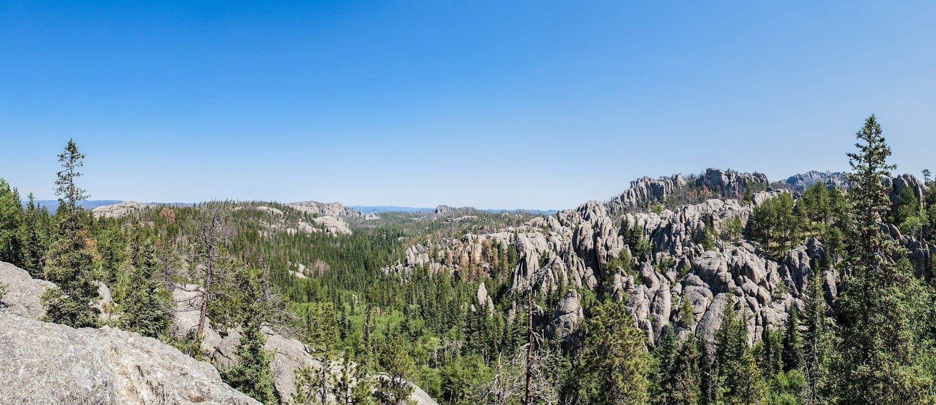
3. Cathedral Spires Trail
After seeing the spires from afar on Needles Highway and on the previous hiking trails, take the opportunity to walk among the spires of Custer State Park on the Cathedral Spires Trail.
It is possible to access the trail from the southeastern most corner of the Sylvan Lake parking with Trail #4 (the easier route), but I recommend driving about two miles east on the Needles Highway (Hwy 87) to the Cathedral Spires Trailhead. From there, the trail is 1.1 miles one-way.
The trail starts off deceivingly flat, then gradually increases elevation, requiring some scrambling up the rocks and making it a strenuous trail. Don’t worry, though. Once you experience the grandeur that Mother Nature put into these towering beasts, it won’t be hard to find motivation to keep going.
4. Sylvan Lake Shore Trail
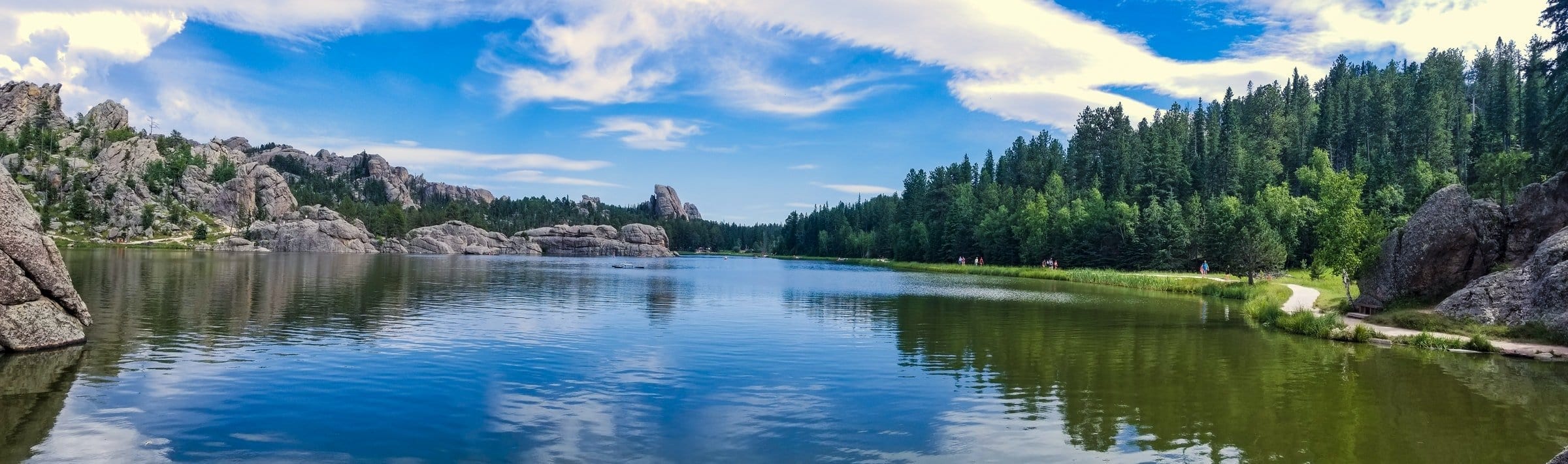
The Sylvan Lake Shore Trail is a very easy 1 mile hike around Sylvan Lake. But don’t take “easy” as “uneventful.”
The loop allows you to experience the peacefulness of the granite as it reflects in the water, and families swim and kayak at the shore. The trail is mostly flat, except for when you get closer to the dam, it begins to go through a tunnel and up into the rocks. You can climb up the rock formations as well to get an even better view of Sylvan Lake from above.
If you don’t have time for any other hiking trails in Custer State Park, I recommend at least stopping for a quick 30 minutes to do this trail.
5. Sunday Gulch Trail
Unlike the previous trails, Sunday Gulch Trail is a little more hidden with less hikers. However, the hikers who do make it out to the gulch will be rewarded with an exciting hike over boulders and a creek, and through the lush hillside full of forestry and wildflowers.
From the Sylvan Lake Shore Trail, head behind the Sylvan Lake dam to find the trailhead for the Sunday Gulch Trail. If you start the loop counter-clockwise, entering on the right (just behind the sign), the trail immediately goes down some steep and slippery boulders with some handrails as you descend with the creek. For this reason, some hikers recommend starting at the opposite end to hike the trail clockwise, requiring you to climb up the slippery rocks at the end of the trail, instead of down them. Doing so also offers a better view of the beautiful rock formations.
When I hiked Sunday Gulch, I did the trail counter-clockwise and got my shoes wet while going down the creek. I would’ve preferred to leave that for the end, so I wasn’t hiking the full 2.8 miles with wet feet, but take your skill level and the weather into consideration when deciding which option to take.
The boulders are the most strenuous part of the trail. Besides that, I would rate the remainder of the trail as moderate to easy. Once you are down the gulch, you will find yourself with a great overlook of the Black Hills National Forest, as the trail weaves through a few of the spires as well.
In Conclusion
There are actually a ton of hiking trails in Custer State Park. These are just the most popular ones. I may write a post in the future about some of the lesser-known trails, which are just as amazing. So do stick around for that. Meanwhile, please remember to always be respectful and protect our land so that everyone can enjoy its beauty. Follow the “Leave No Trace” guidelines, pack out what you pack in, and report any suspicious activity to park rangers.
If you have any specific questions about Custer, leave them in the comments section below. For more information about traveling to South Dakota, check out my Complete South Dakota Travel Guide.
Until next time, happy hiking and I hope to see you out there on the trails!
Comments are closed.